
Defining Geometry
StreetLight Advanced Traffic Counts API
There are multiple methods to define the geometry that dictates the segments you are querying. You will use one of these methods to define geometry when you count segments, verify geometry, or request metrics with the StreetLight Advanced Traffic Counts API. We recommend defining your geometry using the same method as you call different StreetLight Advanced Traffic Counts API endpoints.
How are segments defined?
When you request metrics, you define a geometry that contains a set of StreetLight segments. Metrics are delivered for each of these segments, unless they are shorter than the minimum segment lengths described below, or they do not have a large enough sample size to calculate metrics.
StreetLight segments are derived from OSM segments
StreetLight segments are derived from OpenStreetMap (OSM) and split based on intersection and distance rules. The agps data source lets you select between February 2023 and January 2025 vintages; all other data sources use the February 2023 vintage. For more information in the StreetLight Help Center, see Chopped OpenStreetMap (OSM) Segments .
Each StreetLight segment has a segment ID that is a response for the geometry and metrics endpoints. You can also use StreetLight segment IDs to define the geometry you want to analyze. StreetLight segments are not the same as OSM segments, and so StreetLight segment IDs are different from OSM IDs.
Minimum segment lengths
StreetLight segments won't return metrics if they are below a minimum length. The minimum segment length to return metrics is 15 meters for the agps data source and 50 meters for all other data sources.
Setting the OSM vintage
For requests using the agps source with country: us, you define the OSM vintage, or which snapshot of the network defines segment shapes. The server also exposes additional vintages over time (for example 202601 for January 2026); the API error message lists values that are currently accepted.
The following are the usual alignments; confirm against Get metrics for a geometry and your date / date_range:
| Vintage | OSM Snapshot | Typical use |
|---|---|---|
202302 | February 2023 | Periods through roughly late 2024, depending on your query |
202501 | January 2025 | 2025+ periods, when the product supports that vintage for your range |
202601 | January 2026 | Newer periods when the product supports that vintage for your range |
If you specify a date_range in a metrics request that spans months that align to different vintages (for example across the 2024–2025 boundary), you typically pass both relevant vintages in osm_vintage and include osm_vintage in fields.
Segment count and Geometry use year or a single (or, where supported, an explicitly documented) osm_vintage combination; see the API reference for how many vintages are valid in one request. Do not copy multi-vintage metrics patterns to segment/geometry without checking the request rules.
Methods to define geometry
There are multiple ways to define geometry for the area or segments you want to study. You only need to use one of the methods below.
If you enter a coordinate pair to define your geometry, ensure each pair is listed in the order “Longitude, Latitude” in your requests.
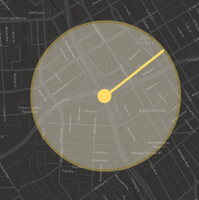
radius
A radius around a point. The point is defined with a pair of latitude and longitude coordinates, and the radius from that point is defined in miles or kilometers.
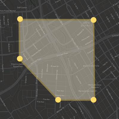
polygon
A bounding polygon defined by at least 4 pairs of coordinates, where the first and last coordinate pair in the array are the same. The polygon includes the area inside the boundary formed by the supplied coordinates.
nearest
Specify a point and a number of segments X to query the nearest X segments to the point. For example, you can use the nearest geometry type with a Get metrics for a geometry request to get metrics for the nearest 10 segments to a potential site.
Use caution when using the
nearestgeometry type and thedate_rangeparameter to get metrics in situations that may have very low sample data, such aspedestriantravel mode withday_partslate at night. This may yield a different selection of segments being returned for each month/year
tract_id, zip_id, blockgroup_id, taz_id
GEOIDs for different local U.S. geographies. For more information, see data.census.gov
places_2020
7-digit numeric code defined by the U.S. Federal Information Processing Series (FIPS), where the first 2 digits are the state FIPS code and the last 5 digits are the place FIPS code. For more information, see www.census.gov
dissemination_area_id, census_division_id, census_subdivision_id
GEOIDs for different Canadian geographies. For more information, see www12.statcan.gc.ca
osm_id
An array of OpenStreetMap IDs defining the road segments you want to analyze. Note that these are different from the segment IDs defined by StreetLight. OSM IDs are not counted by the segmentcount endpoint.
For more information on how StreetLight Data uses OpenStreetMap, see How do changes in OpenStreetMap over time affect StreetLight InSight® ?
segment_id
An array of StreetLight segment IDs defining the road segments you want to analyze. The StreetLight Advanced Traffic Counts API returns traffic metrics for segments defined by Streetlight segment ID.
The geometry endpoint returns StreetLight segment IDs and GeoJSON line strings. You can query the geometry endpoint to determine each segment and geography that is included in the geometry you defined. You can visualize the segments by bringing the output from the geometry endpoint into your GIS tool.
Updated 3 months ago